


Luneville_forêt de Mondon_14km

geranimo
User
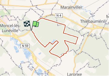

Length
14.5 km

Max alt
274 m

Uphill gradient
86 m
Km-Effort
15.6 km

Min alt
242 m

Downhill gradient
87 m
Boucle
Yes
Creation date :
2020-06-08 18:53:46.219
Updated on :
2020-06-26 18:56:09.666
--
Difficulty : Medium

FREE GPS app for hiking
 SityTrail
IGN / Geographical institutes
SityTrail Plus
The world is yours!
About
Trail On foot of 14.5 km to be discovered at Grand Est, Meurthe-et-Moselle, Moncel-lès-Lunéville. This trail is proposed by geranimo.
Positioning
Country:
France
Region :
Grand Est
Department/Province :
Meurthe-et-Moselle
Municipality :
Moncel-lès-Lunéville
Location:
Unknown
Start:(Dec)
Start:(UTM)
319609 ; 5382805 (32U) N.
Comments