


conde sur seulles 11 kms 2020

aubinjoel
User
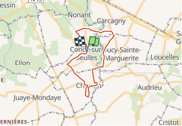

Length
11.1 km

Max alt
81 m

Uphill gradient
106 m
Km-Effort
12.5 km

Min alt
32 m

Downhill gradient
102 m
Boucle
Yes
Creation date :
2020-06-09 09:11:36.445
Updated on :
2020-06-09 09:13:08.394

FREE GPS app for hiking
 SityTrail
IGN / Geographical institutes
SityTrail Plus
The world is yours!
About
Trail of 11.1 km to be discovered at Normandy, Calvados. This trail is proposed by aubinjoel.
Positioning
Country:
France
Region :
Normandy
Department/Province :
Calvados
Municipality :
CONDE-SUR-SEULLES
Location:
Unknown
Start:(Dec)
Start:(UTM)
672193 ; 5455219 (30U) N.
Comments