


Beaumesnil

werth
User
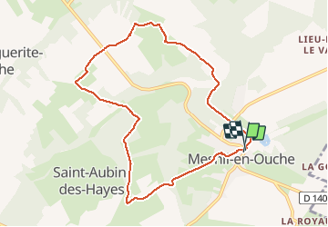

Length
8.6 km

Max alt
174 m

Uphill gradient
107 m
Km-Effort
10 km

Min alt
130 m

Downhill gradient
108 m
Boucle
Yes
Creation date :
2020-06-09 06:55:18.771
Updated on :
2020-06-09 09:17:09.982
2h20
Difficulty : Easy

FREE GPS app for hiking
 SityTrail
IGN / Geographical institutes
SityTrail Plus
The world is yours!
About
Trail Walking of 8.6 km to be discovered at Normandy, Eure, Mesnil-en-Ouche. This trail is proposed by werth.
Photos

Positioning
Country:
France
Region :
Normandy
Department/Province :
Eure
Municipality :
Mesnil-en-Ouche
Location:
Unknown
Start:(Dec)
Start:(UTM)
332350 ; 5431366 (31U) N.
Comments