


CHENEDET LANDEAN ST FRANCOIS POULAILLER 19KM JY

COGLAIS3
User
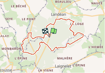

Length
19.7 km

Max alt
210 m

Uphill gradient
271 m
Km-Effort
23 km

Min alt
110 m

Downhill gradient
272 m
Boucle
Yes
Creation date :
2020-06-09 06:15:17.899
Updated on :
2020-06-09 20:40:36.268
3h31
Difficulty : Very easy

FREE GPS app for hiking
 SityTrail
IGN / Geographical institutes
SityTrail Plus
The world is yours!
About
Trail Nordic walking of 19.7 km to be discovered at Brittany, Ille-et-Vilaine, Landéan. This trail is proposed by COGLAIS3.
Positioning
Country:
France
Region :
Brittany
Department/Province :
Ille-et-Vilaine
Municipality :
Landéan
Location:
Unknown
Start:(Dec)
Start:(UTM)
635923 ; 5361717 (30U) N.
Comments