


Samoëns Corne au taureau plan des Lacs

ramagufa
User
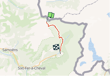

Length
8.8 km

Max alt
2569 m

Uphill gradient
26 m
Km-Effort
14.5 km

Min alt
959 m

Downhill gradient
1630 m
Boucle
No
Creation date :
2020-06-10 07:16:30.176
Updated on :
2020-06-15 13:42:26.06
1h52
Difficulty : Medium

FREE GPS app for hiking
 SityTrail
IGN / Geographical institutes
SityTrail Plus
The world is yours!
About
Trail Walking of 8.8 km to be discovered at Auvergne-Rhône-Alpes, Upper Savoy, Sixt-Fer-à-Cheval. This trail is proposed by ramagufa.
Positioning
Country:
France
Region :
Auvergne-Rhône-Alpes
Department/Province :
Upper Savoy
Municipality :
Sixt-Fer-à-Cheval
Location:
Unknown
Start:(Dec)
Start:(UTM)
330794 ; 5110521 (32T) N.
Comments