


VTT avec Gilles Technique

domifon
User

Length
28 km

Max alt
136 m

Uphill gradient
468 m
Km-Effort
34 km

Min alt
27 m

Downhill gradient
466 m
Boucle
No
Creation date :
2020-06-10 14:21:52.0
Updated on :
2020-06-10 16:42:49.756
2h15
Difficulty : Very difficult

FREE GPS app for hiking
 SityTrail
IGN / Geographical institutes
SityTrail Plus
The world is yours!
About
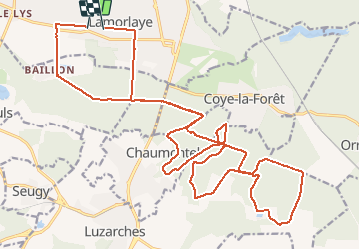
Trail Mountain bike of 28 km to be discovered at Hauts-de-France, Oise, Lamorlaye. This trail is proposed by domifon.
Positioning
Country:
France
Region :
Hauts-de-France
Department/Province :
Oise
Municipality :
Lamorlaye
Location:
Unknown
Start:(Dec)
Start:(UTM)
457215 ; 5445229 (31U) N.
Comments