


2020-06-10_23h34m31_iti0034

jeanic63
User
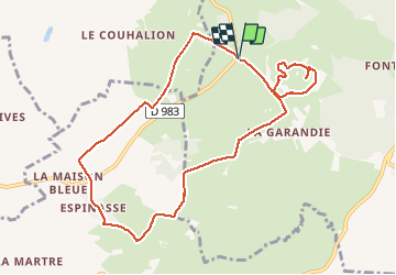

Length
9.9 km

Max alt
1114 m

Uphill gradient
215 m
Km-Effort
12.8 km

Min alt
987 m

Downhill gradient
217 m
Boucle
Yes
Creation date :
2020-06-10 21:34:33.43
Updated on :
2020-07-31 14:04:14.577
--
Difficulty : Medium

FREE GPS app for hiking
 SityTrail
IGN / Geographical institutes
SityTrail Plus
The world is yours!
About
Trail On foot of 9.9 km to be discovered at Auvergne-Rhône-Alpes, Puy-de-Dôme, Aydat. This trail is proposed by jeanic63.
Description
départ parking sur la D983
Positioning
Country:
France
Region :
Auvergne-Rhône-Alpes
Department/Province :
Puy-de-Dôme
Municipality :
Aydat
Location:
Unknown
Start:(Dec)
Start:(UTM)
495241 ; 5057256 (31T) N.
Comments