


Romeu et

raygautier
User
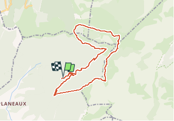

Length
19.8 km

Max alt
1824 m

Uphill gradient
1081 m
Km-Effort
34 km

Min alt
1004 m

Downhill gradient
1089 m
Boucle
Yes
Creation date :
2020-06-11 07:04:32.0
Updated on :
2020-06-11 16:30:25.21
4h44
Difficulty : Unknown

FREE GPS app for hiking
 SityTrail
IGN / Geographical institutes
SityTrail Plus
The world is yours!
About
Trail Walking of 19.8 km to be discovered at Auvergne-Rhône-Alpes, Drôme, Romeyer. This trail is proposed by raygautier.
Positioning
Country:
France
Region :
Auvergne-Rhône-Alpes
Department/Province :
Drôme
Municipality :
Romeyer
Location:
Unknown
Start:(Dec)
Start:(UTM)
693435 ; 4964311 (31T) N.
Comments