


ITI0084

jeanic63
User

Length
14.8 km

Max alt
1193 m

Uphill gradient
489 m
Km-Effort
21 km

Min alt
886 m

Downhill gradient
491 m
Boucle
Yes
Creation date :
2020-06-12 08:55:09.465
Updated on :
2020-06-12 09:23:10.753
--
Difficulty : Medium

FREE GPS app for hiking
 SityTrail
IGN / Geographical institutes
SityTrail Plus
The world is yours!
About
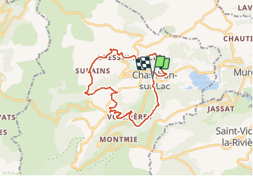
Trail On foot of 14.8 km to be discovered at Auvergne-Rhône-Alpes, Puy-de-Dôme, Chambon-sur-Lac. This trail is proposed by jeanic63.
Description
Départ Chambon sur lac place de la fontaine
Positioning
Country:
France
Region :
Auvergne-Rhône-Alpes
Department/Province :
Puy-de-Dôme
Municipality :
Chambon-sur-Lac
Location:
Unknown
Start:(Dec)
Start:(UTM)
491965 ; 5046458 (31T) N.
Comments