


SY 1

fputters
User
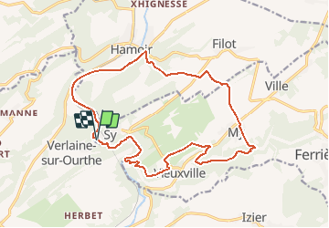

Length
17 km

Max alt
284 m

Uphill gradient
374 m
Km-Effort
22 km

Min alt
113 m

Downhill gradient
374 m
Boucle
Yes
Creation date :
2020-06-12 13:39:24.655
Updated on :
2020-06-12 13:44:23.74
4h43
Difficulty : Very difficult

FREE GPS app for hiking
 SityTrail
IGN / Geographical institutes
SityTrail Plus
The world is yours!
About
Trail Walking of 17 km to be discovered at Wallonia, Liège, Ferrières. This trail is proposed by fputters.
Description
Jeudi sain 20 06 11
JEAN Marie Francine, Geneviève, Jacqueline, Michel, Robert F
Ma tablette a enregistré 18.3 Km
Positioning
Country:
Belgium
Region :
Wallonia
Department/Province :
Liège
Municipality :
Ferrières
Location:
Vieuxville
Start:(Dec)
Start:(UTM)
679118 ; 5586527 (31U) N.
Comments