


11.06.20 -Gaschney-Frankenthal-Trois Four-Falimont-Gaschney

delm
User
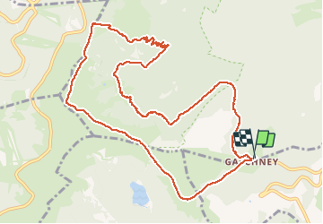

Length
12.3 km

Max alt
1338 m

Uphill gradient
521 m
Km-Effort
19.2 km

Min alt
964 m

Downhill gradient
526 m
Boucle
Yes
Creation date :
2020-06-12 10:03:44.0
Updated on :
2020-06-13 10:46:33.212
4h22
Difficulty : Very difficult

FREE GPS app for hiking
 SityTrail
IGN / Geographical institutes
SityTrail Plus
The world is yours!
About
Trail Walking of 12.3 km to be discovered at Grand Est, Haut-Rhin, Stosswihr. This trail is proposed by delm.
Description
Tre belle randonnée .Très variée, parie forêt et crête.
Une magnifique vue à l'Auberge de Frankenthal
Positioning
Country:
France
Region :
Grand Est
Department/Province :
Haut-Rhin
Municipality :
Stosswihr
Location:
Unknown
Start:(Dec)
Start:(UTM)
354396 ; 5321983 (32U) N.
Comments