


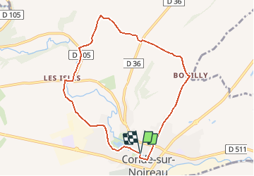
Condé sur Noireau-01

gr1346
User

Length
7.8 km

Max alt
156 m

Uphill gradient
156 m
Km-Effort
9.9 km

Min alt
78 m

Downhill gradient
157 m
Boucle
Yes
Creation date :
2014-12-10 00:00:00.0
Updated on :
2014-12-10 00:00:00.0
2h08
Difficulty : Medium

FREE GPS app for hiking
 SityTrail
IGN / Geographical institutes
SityTrail Plus
The world is yours!
About
Trail Walking of 7.8 km to be discovered at Normandy, Calvados, Condé-en-Normandie. This trail is proposed by gr1346.
Positioning
Country:
France
Region :
Normandy
Department/Province :
Calvados
Municipality :
Condé-en-Normandie
Location:
Unknown
Start:(Dec)
Start:(UTM)
679484 ; 5413838 (30U) N.
Comments
belle rando