


Izeron - Des cascades à la Madonne

Sigmut
User
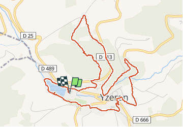

Length
7.1 km

Max alt
858 m

Uphill gradient
276 m
Km-Effort
10.8 km

Min alt
611 m

Downhill gradient
276 m
Boucle
Yes
Creation date :
2020-06-14 11:28:32.967
Updated on :
2020-07-30 21:33:11.213
3h33
Difficulty : Easy

FREE GPS app for hiking
 SityTrail
IGN / Geographical institutes
SityTrail Plus
The world is yours!
About
Trail Walking of 7.1 km to be discovered at Auvergne-Rhône-Alpes, Rhône, Yzeron. This trail is proposed by Sigmut.
Description
Rando variée belle et agréable avec un enfant de 3 ans et un autre de 5 ans
Photos


24 photos in total. Please click on a photo to see them all in the gallery.
Positioning
Country:
France
Region :
Auvergne-Rhône-Alpes
Department/Province :
Rhône
Municipality :
Yzeron
Location:
Unknown
Start:(Dec)
Start:(UTM)
623229 ; 5062857 (31T) N.
Comments