


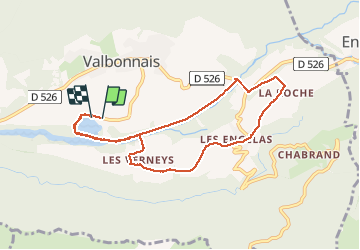
Valbonnais - Les Angelas

maupassant38
User

Length
8.9 km

Max alt
808 m

Uphill gradient
130 m
Km-Effort
10.6 km

Min alt
703 m

Downhill gradient
130 m
Boucle
Yes
Creation date :
2020-06-14 09:19:43.951
Updated on :
2020-09-07 13:48:22.33
1h57
Difficulty : Very easy

FREE GPS app for hiking
 SityTrail
IGN / Geographical institutes
SityTrail Plus
The world is yours!
About
Trail Walking of 8.9 km to be discovered at Auvergne-Rhône-Alpes, Isère, Valbonnais. This trail is proposed by maupassant38.
Positioning
Country:
France
Region :
Auvergne-Rhône-Alpes
Department/Province :
Isère
Municipality :
Valbonnais
Location:
Unknown
Start:(Dec)
Start:(UTM)
729112 ; 4975159 (31T) N.
Comments