


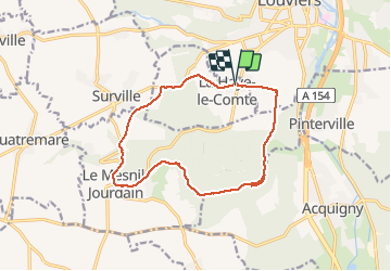
La Haye-le-Comte par la forêt du Becdal

MichelRando7656
User


4h08
Difficulty : Difficult

FREE GPS app for hiking
 SityTrail
IGN / Geographical institutes
SityTrail Plus
The world is yours!
About
Trail Walking of 13.3 km to be discovered at Normandy, Eure, La Haye-le-Comte. This trail is proposed by MichelRando7656.
Description
Beaux chemins forestiers ou à travers la plaine , les champs de lin, de colza ou de céréales et de betteraves
Quelques petites routes goudronnées.
Le regret les sentiers du secteurs du Becdal barrés par des arbres et des branchages.
Photos


Positioning
Comments