


Crêt de l'aigle

Bogapuki
User
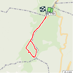

Length
5 km

Max alt
1657 m

Uphill gradient
194 m
Km-Effort
7.6 km

Min alt
1576 m

Downhill gradient
190 m
Boucle
Yes
Creation date :
2018-11-25 09:19:37.512
Updated on :
2018-11-25 09:19:37.512
1h34
Difficulty : Very easy

FREE GPS app for hiking
 SityTrail
IGN / Geographical institutes
SityTrail Plus
The world is yours!
About
Trail Walking of 5 km to be discovered at Auvergne-Rhône-Alpes, Upper Savoy, Leschaux. This trail is proposed by Bogapuki.
Description
22 janvier 2014
Rando/raquette facile par un temps superbe, offrant un panorama fabuleux sur les Alpes et le Mont Blanc (of course).
Positioning
Country:
France
Region :
Auvergne-Rhône-Alpes
Department/Province :
Upper Savoy
Municipality :
Leschaux
Location:
Unknown
Start:(Dec)
Start:(UTM)
274757 ; 5075156 (32T) N.
Comments
Bonne petite balade familiale