


ARRENES-BENEVENT

csy95
User
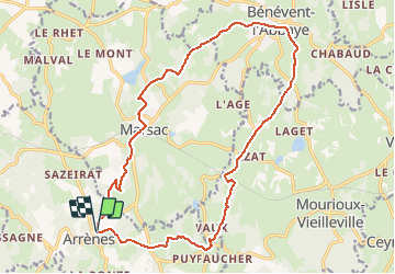

Length
19.2 km

Max alt
529 m

Uphill gradient
420 m
Km-Effort
25 km

Min alt
362 m

Downhill gradient
418 m
Boucle
Yes
Creation date :
2020-06-18 17:14:44.18
Updated on :
2020-06-18 17:15:58.675
5h19
Difficulty : Very difficult

FREE GPS app for hiking
 SityTrail
IGN / Geographical institutes
SityTrail Plus
The world is yours!
About
Trail Walking of 19.2 km to be discovered at New Aquitaine, Creuse, Arrènes. This trail is proposed by csy95.
Description
BOUCLE ENTRE ARRENES ET BENEVENT
Positioning
Country:
France
Region :
New Aquitaine
Department/Province :
Creuse
Municipality :
Arrènes
Location:
Unknown
Start:(Dec)
Start:(UTM)
389551 ; 5103118 (31T) N.
Comments