


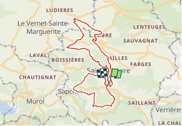
saint nectaire les grottes de chateauneuf et les granges

jeanic63
User

Length
21 km

Max alt
982 m

Uphill gradient
697 m
Km-Effort
30 km

Min alt
682 m

Downhill gradient
699 m
Boucle
Yes
Creation date :
2020-06-19 09:25:11.608
Updated on :
2022-04-17 16:27:38.902
--
Difficulty : Difficult

FREE GPS app for hiking
 SityTrail
IGN / Geographical institutes
SityTrail Plus
The world is yours!
About
Trail On foot of 21 km to be discovered at Auvergne-Rhône-Alpes, Puy-de-Dôme, Saint-Nectaire. This trail is proposed by jeanic63.
Description
départ saint nectaire
Positioning
Country:
France
Region :
Auvergne-Rhône-Alpes
Department/Province :
Puy-de-Dôme
Municipality :
Saint-Nectaire
Location:
Unknown
Start:(Dec)
Start:(UTM)
499475 ; 5047573 (31T) N.
Comments