


passage de picheru

whisper73
User
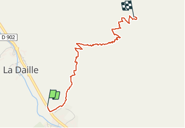

Length
3.2 km

Max alt
2563 m

Uphill gradient
752 m
Km-Effort
10.7 km

Min alt
1804 m

Downhill gradient
0 m
Boucle
No
Creation date :
2020-06-20 06:33:57.323
Updated on :
2020-06-20 09:21:45.705
1h25
Difficulty : Very easy
15m
Difficulty : Easy

FREE GPS app for hiking
 SityTrail
IGN / Geographical institutes
SityTrail Plus
The world is yours!
About
Trail Walking of 3.2 km to be discovered at Auvergne-Rhône-Alpes, Savoy, Val-d'Isère. This trail is proposed by whisper73.
Positioning
Country:
France
Region :
Auvergne-Rhône-Alpes
Department/Province :
Savoy
Municipality :
Val-d'Isère
Location:
Unknown
Start:(Dec)
Start:(UTM)
341237 ; 5035605 (32T) N.
Comments