


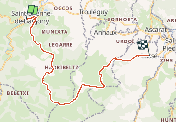
GR10 - Bigorry - Lasse

winkelmuller
User

Length
16.3 km

Max alt
1015 m

Uphill gradient
975 m
Km-Effort
29 km

Min alt
155 m

Downhill gradient
932 m
Boucle
No
Creation date :
2020-06-20 05:09:51.508
Updated on :
2020-06-20 13:38:06.899
8h25
Difficulty : Medium

FREE GPS app for hiking
 SityTrail
IGN / Geographical institutes
SityTrail Plus
The world is yours!
About
Trail Walking of 16.3 km to be discovered at New Aquitaine, Pyrénées-Atlantiques, Saint-Étienne-de-Baïgorry. This trail is proposed by winkelmuller.
Positioning
Country:
France
Region :
New Aquitaine
Department/Province :
Pyrénées-Atlantiques
Municipality :
Saint-Étienne-de-Baïgorry
Location:
Unknown
Start:(Dec)
Start:(UTM)
634359 ; 4781597 (30T) N.
Comments