


Enval - Facemeunier - Tournoel

jeanic63
User
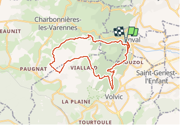

Length
16.7 km

Max alt
797 m

Uphill gradient
481 m
Km-Effort
23 km

Min alt
443 m

Downhill gradient
484 m
Boucle
Yes
Creation date :
2020-06-20 14:06:35.921
Updated on :
2020-07-23 15:20:21.831
--
Difficulty : Medium

FREE GPS app for hiking
 SityTrail
IGN / Geographical institutes
SityTrail Plus
The world is yours!
About
Trail On foot of 16.7 km to be discovered at Auvergne-Rhône-Alpes, Puy-de-Dôme, Enval. This trail is proposed by jeanic63.
Description
départ Enval parking D15 dans le virage en épingle à cheveux
Positioning
Country:
France
Region :
Auvergne-Rhône-Alpes
Department/Province :
Puy-de-Dôme
Municipality :
Enval
Location:
Unknown
Start:(Dec)
Start:(UTM)
503563 ; 5082772 (31T) N.
Comments