


1er jour 2020

planets
User
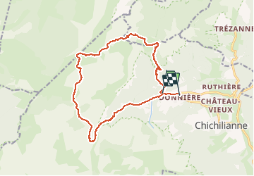

Length
17.5 km

Max alt
1904 m

Uphill gradient
903 m
Km-Effort
30 km

Min alt
1020 m

Downhill gradient
959 m
Boucle
No
Creation date :
2020-06-20 07:06:56.252
Updated on :
2020-06-20 16:09:30.228
5h01
Difficulty : Medium

FREE GPS app for hiking
 SityTrail
IGN / Geographical institutes
SityTrail Plus
The world is yours!
About
Trail Walking of 17.5 km to be discovered at Auvergne-Rhône-Alpes, Isère, Chichilianne. This trail is proposed by planets.
Positioning
Country:
France
Region :
Auvergne-Rhône-Alpes
Department/Province :
Isère
Municipality :
Chichilianne
Location:
Unknown
Start:(Dec)
Start:(UTM)
701199 ; 4966415 (31T) N.
Comments