


Burg-Reuland - Balade 29 - Guide de l'Ardenne du Nord

AnneCecile
User

Length
11.2 km

Max alt
495 m

Uphill gradient
245 m
Km-Effort
14.5 km

Min alt
350 m

Downhill gradient
245 m
Boucle
Yes
Creation date :
2020-06-20 20:33:36.918
Updated on :
2020-06-20 20:49:32.531
--
Difficulty : Very easy

FREE GPS app for hiking
 SityTrail
IGN / Geographical institutes
SityTrail Plus
The world is yours!
About
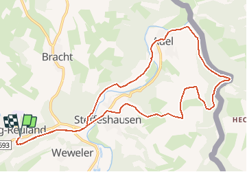
Trail On foot of 11.2 km to be discovered at Wallonia, Liège, Burg-Reuland. This trail is proposed by AnneCecile.
Description
Situation: Burg-Reuland
Parking : à l'entrée du village sur la droite
Balisage : rectangle jaune
Départ : dans le centre de Burg-Reuland suivez les panneau Ravel
Positioning
Country:
Belgium
Region :
Wallonia
Department/Province :
Liège
Municipality :
Burg-Reuland
Location:
Reuland
Start:(Dec)
Start:(UTM)
295600 ; 5564311 (32U) N.
Comments