


Nandy_Foret de Rougeau__3222648

gdela
User
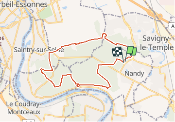

Length
16.2 km

Max alt
102 m

Uphill gradient
142 m
Km-Effort
18.1 km

Min alt
60 m

Downhill gradient
142 m
Boucle
Yes
Creation date :
2020-06-20 20:41:19.356
Updated on :
2020-06-20 20:45:26.204
--
Difficulty : Medium

FREE GPS app for hiking
 SityTrail
IGN / Geographical institutes
SityTrail Plus
The world is yours!
About
Trail On foot of 16.2 km to be discovered at Ile-de-France, Seine-et-Marne, Nandy. This trail is proposed by gdela.
Positioning
Country:
France
Region :
Ile-de-France
Department/Province :
Seine-et-Marne
Municipality :
Nandy
Location:
Unknown
Start:(Dec)
Start:(UTM)
467348 ; 5381635 (31U) N.
Comments