Trail Walking Lédenon - LOGRIAN - BOIS DE ROUCAUTE - 15.1Km - 05h00 - Dénivelé 200 m - Photo

LOGRIAN - BOIS DE ROUCAUTE - 15.1Km - 05h00 - Dénivelé 200 m

© OpenStreetMap contributors
Length
Length
16.7 km
Max alt
Max alt
154 m
Uphill gradient
Uphill gradient
385 m
Km-Effort
Km-Effort  
22 km
Min alt
Min alt
28 m
Downhill gradient
Downhill gradient
386 m
Boucle
Boucle
Yes
Creation date :
2014-12-10 00:00:00.0
Updated on :
2014-12-10 00:00:00.0

(0 Reviews)

Walking
Walking
4h41
Difficulty : Medium

Scan this QR Code to open this trail in the SityTrail application

FREE GPS app for hiking

Logo SityTrail SityTrail

IGN / Geographical institutes

Download SityTrail from the App Store Download SityTrail from Google Play

Logo SityTrail SityTrail World

The world is yours!

Download SityTrail from the App Store Download SityTrail from Google Play Download SityTrail on Huawei AppGallery

About

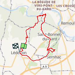
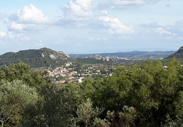
Trail Walking of 16.7 km to be discovered at Occitania, Gard, Lédenon. This trail is proposed by dansmabulle.

Description

LOGRIAN - BOIS DE ROUCAUTE
15.1Km - 05h00
Départ randonnée : A partir de Quissac prendre la direction Anduze par la D35, au bout de 5km tourner à droite vers Logrian par la D8. A logrian à l'entrée du village se garer juste après le pont sur une petite place. Logrian, Le Bois de Roucaute. 15,5 km durée 5h. Pas de difficulté, peu de balisage(ancien)La randonnée commence sur un bon kilomètre en empruntant la route D8 en direction de Savignargue, et ensuite à droite en suivant la trace GPS.Ne pas oublier de faire un aller retour vers les ruines du château juché sur un éperon rocheux avec une vue magnifique sur 360°.Après le bois, les ruines et les vignes le tracé nous permet de découvrir le lac de la Rouvière. Le retour au village de Logrian se fait par les collines.Eviter les périodes de chasse.Une randonnée sympathique en hiver ou en demi-saison.

Elevation profile

Positioning

Country:
France
Region :
Occitania
Department/Province :
Gard
Municipality :
Lédenon
Location:
Unknown
Start:(UTM)
621314 ; 4863541 (31T) N.

Trails nearby

Trail Walking Vers-Pont-du-Gard - Rando pont du Gard - Photo
Walking
SabetMick

Walking

Easy
(1)
Vers-Pont-du-Gard, Occitania, Gard, France
6.8 km | 8.6 km-effort
2h 49min
No
Trail Walking Saint-Bonnet-du-Gard - Le Pont du Gard - Photo
Walking
VacheKiri67

Walking

Difficult
(2)
Saint-Bonnet-du-Gard, Occitania, Gard, France
18.6 km | 24 km-effort
5h 30min
Yes
Trail Walking Collias - La Baume par Collias - Photo
Walking
tracegps

Walking

Medium
(2)
Collias, Occitania, Gard, France
13.3 km | 18.1 km-effort
4h 0min
Yes
Trail Walking Collias - PF-Collias - Les Gorges du Gardon - Photo
Walking
MicDul

Walking

Easy
(1)
Collias, Occitania, Gard, France
12.9 km | 16.4 km-effort
3h 39min
Yes
Trail Walking Saint-Bonnet-du-Gard - Chemins oubliés de l'Aqueduc  - Photo
Walking
GUIDE
nadinebondoux

Walking

Medium
Saint-Bonnet-du-Gard, Occitania, Gard, France
12.7 km | 16.5 km-effort
3h 39min
Yes
Trail On foot Collias - L'Ermitage de Collias - Photo
On foot
PRO

On foot

Easy
Collias, Occitania, Gard, France
5.3 km | 7 km-effort
1h 35min
No
Trail Walking Lédenon - Sernhac / Saint Bonnet /Pont du Gard/ Ledenon - Photo
Walking
GUIDE
nadinebondoux

Walking

Medium
Lédenon, Occitania, Gard, France
18.7 km | 25 km-effort
5h 23min
Yes
Trail Walking Saint-Bonnet-du-Gard - SAINT BONNET DU GARD - PONT DU GARD - Variante - 15.8Km 05h00 - Dénivelé 410 m - Photo
Walking
dansmabulle

Walking

Difficult
(3)
Saint-Bonnet-du-Gard, Occitania, Gard, France
15.8 km | 21 km-effort
4h 30min
Yes
Trail Walking Collias - COLLIAS - ROCHERS TROUES - ERMITAGE LAVAL-COLIAS - 13.6Km - 04h00 - Dénivelé 250 m - Photo
Walking
dansmabulle

Walking

Medium
(1)
Collias, Occitania, Gard, France
13.6 km | 18.1 km-effort
3h 57min
Yes


Close
My subscriptions