


Mouthier Haute Pierre

grasgilbert
User
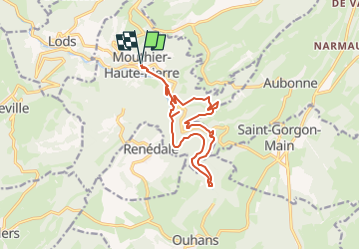

Length
14.1 km

Max alt
743 m

Uphill gradient
656 m
Km-Effort
23 km

Min alt
377 m

Downhill gradient
656 m
Boucle
Yes
Creation date :
2020-06-22 08:12:06.494
Updated on :
2023-05-22 11:51:54.37
5h11
Difficulty : Medium

FREE GPS app for hiking
 SityTrail
IGN / Geographical institutes
SityTrail Plus
The world is yours!
About
Trail On foot of 14.1 km to be discovered at Bourgogne-Franche-Comté, Doubs, Mouthier-Haute-Pierre. This trail is proposed by grasgilbert.
Description
la source de la Loue
Positioning
Country:
France
Region :
Bourgogne-Franche-Comté
Department/Province :
Doubs
Municipality :
Mouthier-Haute-Pierre
Location:
Unknown
Start:(Dec)
Start:(UTM)
292989 ; 5213229 (32T) N.
Comments
très très très dure