


marcillac st Quentin La Coste

Laurent53
User
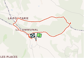

Length
5.2 km

Max alt
269 m

Uphill gradient
123 m
Km-Effort
6.8 km

Min alt
173 m

Downhill gradient
124 m
Boucle
Yes
Creation date :
2020-06-20 14:50:23.637
Updated on :
2020-06-29 10:24:14.872
1h30
Difficulty : Very easy

FREE GPS app for hiking
 SityTrail
IGN / Geographical institutes
SityTrail Plus
The world is yours!
About
Trail Walking of 5.2 km to be discovered at New Aquitaine, Dordogne, Marcillac-Saint-Quentin. This trail is proposed by Laurent53.
Positioning
Country:
France
Region :
New Aquitaine
Department/Province :
Dordogne
Municipality :
Marcillac-Saint-Quentin
Location:
Unknown
Start:(Dec)
Start:(UTM)
359226 ; 4980831 (31T) N.
Comments