


le signal

tgvpatrickfavre
User

Length
12.1 km

Max alt
1123 m

Uphill gradient
872 m
Km-Effort
24 km

Min alt
480 m

Downhill gradient
874 m
Boucle
Yes
Creation date :
2014-12-10 00:00:00.0
Updated on :
2014-12-10 00:00:00.0
3h45
Difficulty : Medium

FREE GPS app for hiking
 SityTrail
IGN / Geographical institutes
SityTrail Plus
The world is yours!
About
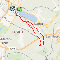
Trail Walking of 12.1 km to be discovered at Auvergne-Rhône-Alpes, Ain, Port. This trail is proposed by tgvpatrickfavre.
Description
depuis Port avec passage å nantua
Positioning
Country:
France
Region :
Auvergne-Rhône-Alpes
Department/Province :
Ain
Municipality :
Port
Location:
Unknown
Start:(Dec)
Start:(UTM)
698624 ; 5115347 (31T) N.
Comments
ballade à faire connaître vue splendide sur Nantua