


Balade dans le Lys

domifon
User
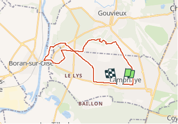

Length
13.7 km

Max alt
58 m

Uphill gradient
90 m
Km-Effort
14.9 km

Min alt
24 m

Downhill gradient
91 m
Boucle
No
Creation date :
2020-06-22 15:49:20.0
Updated on :
2020-06-22 16:32:01.872
42m
Difficulty : Unknown

FREE GPS app for hiking
 SityTrail
IGN / Geographical institutes
SityTrail Plus
The world is yours!
About
Trail Mountain bike of 13.7 km to be discovered at Hauts-de-France, Oise, Lamorlaye. This trail is proposed by domifon.
Positioning
Country:
France
Region :
Hauts-de-France
Department/Province :
Oise
Municipality :
Lamorlaye
Location:
Unknown
Start:(Dec)
Start:(UTM)
457896 ; 5445163 (31U) N.
Comments