


2020-06-23_14h20m28_GgB4n8RoXh0

raab
User
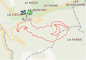

Length
6.3 km

Max alt
806 m

Uphill gradient
271 m
Km-Effort
9.9 km

Min alt
638 m

Downhill gradient
273 m
Boucle
Yes
Creation date :
2020-06-23 12:20:28.427
Updated on :
2020-06-23 12:27:34.936
--
Difficulty : Very easy

FREE GPS app for hiking
 SityTrail
IGN / Geographical institutes
SityTrail Plus
The world is yours!
About
Trail On foot of 6.3 km to be discovered at Auvergne-Rhône-Alpes, Ardèche, Aizac. This trail is proposed by raab.
Positioning
Country:
France
Region :
Auvergne-Rhône-Alpes
Department/Province :
Ardèche
Municipality :
Aizac
Location:
Unknown
Start:(Dec)
Start:(UTM)
605352 ; 4952040 (31T) N.
Comments