


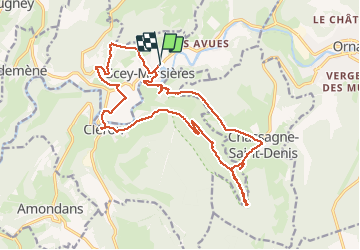
Scey en Varais Ravin de Valbois

TRIMAILLE
User

Length
21 km

Max alt
562 m

Uphill gradient
662 m
Km-Effort
30 km

Min alt
313 m

Downhill gradient
663 m
Boucle
Yes
Creation date :
2020-06-23 06:53:06.472
Updated on :
2020-06-23 13:57:57.36
7h01
Difficulty : Very easy

FREE GPS app for hiking
 SityTrail
IGN / Geographical institutes
SityTrail Plus
The world is yours!
About
Trail Walking of 21 km to be discovered at Bourgogne-Franche-Comté, Doubs, Scey-Maisières. This trail is proposed by TRIMAILLE.
Photos


Positioning
Country:
France
Region :
Bourgogne-Franche-Comté
Department/Province :
Doubs
Municipality :
Scey-Maisières
Location:
Unknown
Start:(Dec)
Start:(UTM)
278292 ; 5220645 (32T) N.
Comments