


Chamrousse

maupassant38
User
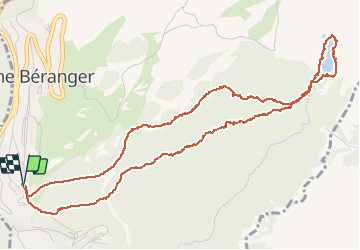

Length
6.5 km

Max alt
1948 m

Uphill gradient
233 m
Km-Effort
9.6 km

Min alt
1730 m

Downhill gradient
233 m
Boucle
Yes
Creation date :
2020-06-23 08:27:43.78
Updated on :
2020-06-23 14:39:23.297
2h04
Difficulty : Easy

FREE GPS app for hiking
 SityTrail
IGN / Geographical institutes
SityTrail Plus
The world is yours!
About
Trail Walking of 6.5 km to be discovered at Auvergne-Rhône-Alpes, Isère, Chamrousse. This trail is proposed by maupassant38.
Positioning
Country:
France
Region :
Auvergne-Rhône-Alpes
Department/Province :
Isère
Municipality :
Chamrousse
Location:
Unknown
Start:(Dec)
Start:(UTM)
726207 ; 4998762 (31T) N.
Comments