


MR_MONTGEenGOELE_5.7km

GOELERANDO2
User
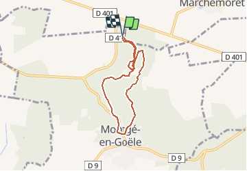

Length
5.7 km

Max alt
209 m

Uphill gradient
107 m
Km-Effort
7.1 km

Min alt
133 m

Downhill gradient
107 m
Boucle
Yes
Creation date :
2020-06-24 08:59:13.692
Updated on :
2020-06-24 09:02:13.263
1h31
Difficulty : Medium

FREE GPS app for hiking
 SityTrail
IGN / Geographical institutes
SityTrail Plus
The world is yours!
About
Trail Walking of 5.7 km to be discovered at Ile-de-France, Seine-et-Marne, Montgé-en-Goële. This trail is proposed by GOELERANDO2.
Description
randonnée au cœur du parc de St Thibault
Positioning
Country:
France
Region :
Ile-de-France
Department/Province :
Seine-et-Marne
Municipality :
Montgé-en-Goële
Location:
Unknown
Start:(Dec)
Start:(UTM)
481654 ; 5432428 (31U) N.
Comments