


Port Cros Mont Vinaigre

Spinnaker
User

Length
9.2 km

Max alt
198 m

Uphill gradient
344 m
Km-Effort
13.8 km

Min alt
0 m

Downhill gradient
341 m
Boucle
Yes
Creation date :
2020-06-24 15:27:06.715
Updated on :
2020-06-24 15:29:58.861
2h50
Difficulty : Difficult

FREE GPS app for hiking
 SityTrail
IGN / Geographical institutes
SityTrail Plus
The world is yours!
About
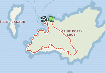
Trail Walking of 9.2 km to be discovered at Provence-Alpes-Côte d'Azur, Var, Hyères. This trail is proposed by Spinnaker.
Positioning
Country:
France
Region :
Provence-Alpes-Côte d'Azur
Department/Province :
Var
Municipality :
Hyères
Location:
Unknown
Start:(Dec)
Start:(UTM)
286704 ; 4765188 (32T) N.
Comments