


Chamarande

gentileadriano
User
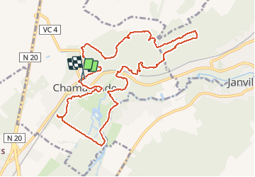

Length
11.7 km

Max alt
164 m

Uphill gradient
193 m
Km-Effort
14.2 km

Min alt
57 m

Downhill gradient
191 m
Boucle
Yes
Creation date :
2020-06-25 06:49:46.525
Updated on :
2020-06-25 16:36:59.351
3h04
Difficulty : Very easy

FREE GPS app for hiking
 SityTrail
IGN / Geographical institutes
SityTrail Plus
The world is yours!
About
Trail Walking of 11.7 km to be discovered at Ile-de-France, Essonne, Chamarande. This trail is proposed by gentileadriano.
Description
parc du château et ses environs.
Positioning
Country:
France
Region :
Ile-de-France
Department/Province :
Essonne
Municipality :
Chamarande
Location:
Unknown
Start:(Dec)
Start:(UTM)
442156 ; 5373808 (31U) N.
Comments