


2372525-Etretat_Fecamp

gdela
User
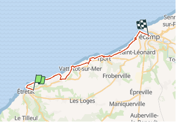

Length
18.2 km

Max alt
98 m

Uphill gradient
378 m
Km-Effort
23 km

Min alt
2 m

Downhill gradient
382 m
Boucle
No
Creation date :
2020-06-26 16:31:14.374
Updated on :
2020-06-26 16:33:06.254
--
Difficulty : Medium

FREE GPS app for hiking
 SityTrail
IGN / Geographical institutes
SityTrail Plus
The world is yours!
About
Trail On foot of 18.2 km to be discovered at Normandy, Seine-Maritime, Étretat. This trail is proposed by gdela.
Positioning
Country:
France
Region :
Normandy
Department/Province :
Seine-Maritime
Municipality :
Étretat
Location:
Unknown
Start:(Dec)
Start:(UTM)
299199 ; 5509931 (31U) N.
Comments