


Ticknock WL route 2014

mickhanney
User
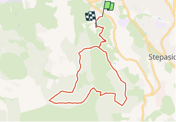

Length
8.2 km

Max alt
463 m

Uphill gradient
331 m
Km-Effort
12.5 km

Min alt
173 m

Downhill gradient
294 m
Boucle
No
Creation date :
2014-12-10 00:00:00.0
Updated on :
2014-12-10 00:00:00.0
--
Difficulty : Difficult

FREE GPS app for hiking
 SityTrail
IGN / Geographical institutes
SityTrail Plus
The world is yours!
About
Trail Running of 8.2 km to be discovered at Unknown, Unknown, Unknown. This trail is proposed by mickhanney.
Positioning
Country:
Ireland
Region :
Unknown
Department/Province :
Unknown
Municipality :
Unknown
Location:
Glencullen ED
Start:(Dec)
Start:(UTM)
684323 ; 5904939 (29U) N.
Comments