Tracé actuel: 18 JUIL 2017 14:05

ZAMBAUX
User
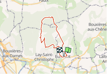

Length
12.1 km

Max alt
379 m

Uphill gradient
292 m
Km-Effort
16 km

Min alt
230 m

Downhill gradient
292 m
Boucle
Yes
Creation date :
2020-06-27 12:30:55.767
Updated on :
2020-06-27 12:35:19.428
3h24
Difficulty : Difficult

FREE GPS app for hiking
 SityTrail
IGN / Geographical institutes
SityTrail Plus
The world is yours!
About
Trail Walking of 12.1 km to be discovered at Grand Est, Meurthe-et-Moselle, Eulmont. This trail is proposed by ZAMBAUX.
Description
La rang du prieuré
Départ : Eglise d'EULMONT
Positioning
Country:
France
Region :
Grand Est
Department/Province :
Meurthe-et-Moselle
Municipality :
Eulmont
Location:
Unknown
Start:(Dec)
Start:(UTM)
295942 ; 5403227 (32U) N.
Comments