


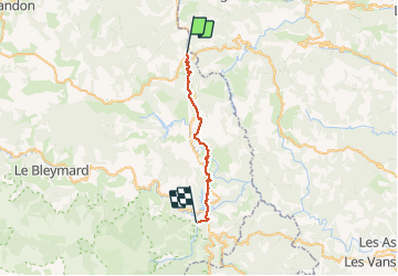
de la bastide puylaurent à villefort gr700

BrassensJC
User

Length
25 km

Max alt
1141 m

Uphill gradient
495 m
Km-Effort
33 km

Min alt
573 m

Downhill gradient
878 m
Boucle
No
Creation date :
2020-06-27 06:16:26.374
Updated on :
2020-06-27 13:42:12.969
7h20
Difficulty : Very difficult

FREE GPS app for hiking
 SityTrail
IGN / Geographical institutes
SityTrail Plus
The world is yours!
About
Trail Walking of 25 km to be discovered at Occitania, Lozère, La Bastide-Puylaurent. This trail is proposed by BrassensJC.
Description
Randonnée difficile suite à la tempête qui a rendue les sentiers impraticables
Temps de parcours incluant les arrêts.
Photos


Positioning
Country:
France
Region :
Occitania
Department/Province :
Lozère
Municipality :
La Bastide-Puylaurent
Location:
Unknown
Start:(Dec)
Start:(UTM)
571878 ; 4937987 (31T) N.
Comments