


20200627

fredodlageo
User
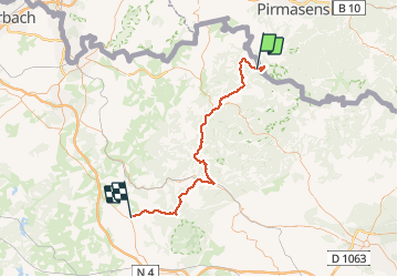

Length
63 km

Max alt
421 m

Uphill gradient
1131 m
Km-Effort
78 km

Min alt
202 m

Downhill gradient
1128 m
Boucle
No
Creation date :
2020-06-27 09:42:24.0
Updated on :
2020-06-28 08:57:39.071
3h30
Difficulty : Unknown

FREE GPS app for hiking
 SityTrail
IGN / Geographical institutes
SityTrail Plus
The world is yours!
About
Trail Walking of 63 km to be discovered at Grand Est, Moselle, Roppeviller. This trail is proposed by fredodlageo.
Description
#Rando canyon #Audrey#Anais#Izzie#karamel
Photos


Positioning
Country:
France
Region :
Grand Est
Department/Province :
Moselle
Municipality :
Roppeviller
Location:
Unknown
Start:(Dec)
Start:(UTM)
391702 ; 5439654 (32U) N.
Comments