


Xhoris rouge minière juin 2020

AnneCecile
User
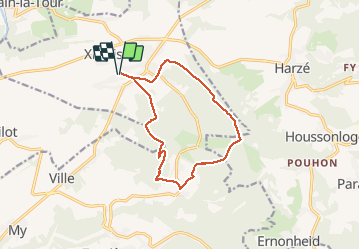

Length
11.5 km

Max alt
377 m

Uphill gradient
222 m
Km-Effort
14.4 km

Min alt
247 m

Downhill gradient
223 m
Boucle
Yes
Creation date :
2020-06-28 07:47:12.0
Updated on :
2020-06-28 10:22:27.477
2h34
Difficulty : Unknown

FREE GPS app for hiking
 SityTrail
IGN / Geographical institutes
SityTrail Plus
The world is yours!
About
Trail Walking of 11.5 km to be discovered at Wallonia, Liège, Ferrières. This trail is proposed by AnneCecile.
Positioning
Country:
Belgium
Region :
Wallonia
Department/Province :
Liège
Municipality :
Ferrières
Location:
Xhoris
Start:(Dec)
Start:(UTM)
685160 ; 5590730 (31U) N.
Comments