


28,06,2020 - Heiligenstein

delm
User
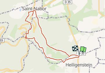

Length
9.1 km

Max alt
583 m

Uphill gradient
356 m
Km-Effort
13.9 km

Min alt
283 m

Downhill gradient
356 m
Boucle
Yes
Creation date :
2020-06-28 13:09:20.0
Updated on :
2020-06-28 17:21:37.46
2h39
Difficulty : Very difficult

FREE GPS app for hiking
 SityTrail
IGN / Geographical institutes
SityTrail Plus
The world is yours!
About
Trail Walking of 9.1 km to be discovered at Grand Est, Bas-Rhin, Obernai. This trail is proposed by delm.
Description
Randonnée assez difficile
Positioning
Country:
France
Region :
Grand Est
Department/Province :
Bas-Rhin
Municipality :
Obernai
Location:
Unknown
Start:(Dec)
Start:(UTM)
385408 ; 5364956 (32U) N.
Comments