


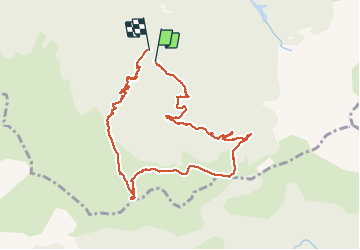
col de la croix

CABERMAT
User

Length
9.7 km

Max alt
1649 m

Uphill gradient
610 m
Km-Effort
17.9 km

Min alt
1024 m

Downhill gradient
624 m
Boucle
Yes
Creation date :
2020-06-28 07:58:31.157
Updated on :
2020-06-28 21:14:21.663
2h52
Difficulty : Very easy

FREE GPS app for hiking
 SityTrail
IGN / Geographical institutes
SityTrail Plus
The world is yours!
About
Trail Walking of 9.7 km to be discovered at Auvergne-Rhône-Alpes, Isère, Tréminis. This trail is proposed by CABERMAT.
Positioning
Country:
France
Region :
Auvergne-Rhône-Alpes
Department/Province :
Isère
Municipality :
Tréminis
Location:
Unknown
Start:(Dec)
Start:(UTM)
719206 ; 4954985 (31T) N.
Comments