


TRACES_VISIBLES

TRIMAILLE
User

Length
22 km

Max alt
832 m

Uphill gradient
700 m
Km-Effort
31 km

Min alt
359 m

Downhill gradient
691 m
Boucle
Yes
Creation date :
2020-06-29 10:00:19.079
Updated on :
2021-01-30 17:46:21.244
6h33
Difficulty : Difficult

FREE GPS app for hiking
 SityTrail
IGN / Geographical institutes
SityTrail Plus
The world is yours!
About
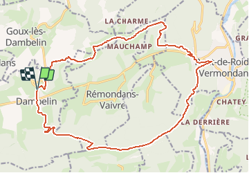
Trail Walking of 22 km to be discovered at Bourgogne-Franche-Comté, Doubs, Dambelin. This trail is proposed by TRIMAILLE.
Description
Départ du parking du cimetière de Dambelin.
Parcours ombragé.
Passage vers les éoliennes du Lomont.
Positioning
Country:
France
Region :
Bourgogne-Franche-Comté
Department/Province :
Doubs
Municipality :
Dambelin
Location:
Unknown
Start:(Dec)
Start:(UTM)
324552 ; 5249884 (32T) N.
Comments