


Deux Rys 290620

guyernage25
User
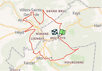

Length
21 km

Max alt
375 m

Uphill gradient
661 m
Km-Effort
30 km

Min alt
168 m

Downhill gradient
657 m
Boucle
Yes
Creation date :
2020-06-29 06:34:04.587
Updated on :
2020-06-29 12:24:01.151
5h07
Difficulty : Medium

FREE GPS app for hiking
 SityTrail
IGN / Geographical institutes
SityTrail Plus
The world is yours!
About
Trail Walking of 21 km to be discovered at Wallonia, Luxembourg, Manhay. This trail is proposed by guyernage25.
Description
vallée de l Aisne
Positioning
Country:
Belgium
Region :
Wallonia
Department/Province :
Luxembourg
Municipality :
Manhay
Location:
Harre
Start:(Dec)
Start:(UTM)
685680 ; 5579847 (31U) N.
Comments