


Col de l étroit du vallon

franquen
User
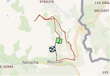

Length
17.6 km

Max alt
2494 m

Uphill gradient
964 m
Km-Effort
31 km

Min alt
1608 m

Downhill gradient
1055 m
Boucle
No
Creation date :
2020-06-29 06:13:12.939
Updated on :
2020-07-01 16:41:18.066
7h34
Difficulty : Medium

FREE GPS app for hiking
 SityTrail
IGN / Geographical institutes
SityTrail Plus
The world is yours!
About
Trail Walking of 17.6 km to be discovered at Provence-Alpes-Côte d'Azur, Hautes-Alpes, Névache. This trail is proposed by franquen.
Positioning
Country:
France
Region :
Provence-Alpes-Côte d'Azur
Department/Province :
Hautes-Alpes
Municipality :
Névache
Location:
Unknown
Start:(Dec)
Start:(UTM)
313436 ; 4989101 (32T) N.
Comments