


Le cirque de Consolation

PhilippeC54
User
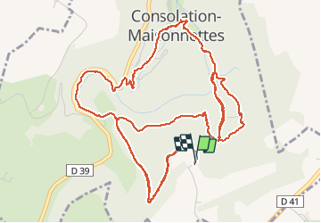

Length
8.4 km

Max alt
846 m

Uphill gradient
487 m
Km-Effort
14.8 km

Min alt
508 m

Downhill gradient
488 m
Boucle
Yes
Creation date :
2020-06-29 11:45:46.367
Updated on :
2020-06-29 14:43:03.357
2h24
Difficulty : Medium

FREE GPS app for hiking
 SityTrail
IGN / Geographical institutes
SityTrail Plus
The world is yours!
About
Trail Walking of 8.4 km to be discovered at Bourgogne-Franche-Comté, Doubs, Consolation-Maisonnettes. This trail is proposed by PhilippeC54.
Positioning
Country:
France
Region :
Bourgogne-Franche-Comté
Department/Province :
Doubs
Municipality :
Consolation-Maisonnettes
Location:
Unknown
Start:(Dec)
Start:(UTM)
318612 ; 5224428 (32T) N.
Comments