


Hatrival01

Thyves
User
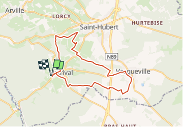

Length
14.2 km

Max alt
492 m

Uphill gradient
252 m
Km-Effort
17.6 km

Min alt
366 m

Downhill gradient
250 m
Boucle
Yes
Creation date :
2020-03-11 21:34:39.874
Updated on :
2024-05-24 16:47:57.203
3h59
Difficulty : Difficult

FREE GPS app for hiking
 SityTrail
IGN / Geographical institutes
SityTrail Plus
The world is yours!
About
Trail Walking of 14.2 km to be discovered at Wallonia, Luxembourg, Saint-Hubert. This trail is proposed by Thyves.
Description
parcours revu le 13 mai 2024
Positioning
Country:
Belgium
Region :
Wallonia
Department/Province :
Luxembourg
Municipality :
Saint-Hubert
Location:
Unknown
Start:(Dec)
Start:(UTM)
667808 ; 5541687 (31U) N.
Comments