


chantraine

randolea
User
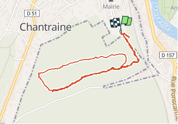

Length
3.2 km

Max alt
443 m

Uphill gradient
82 m
Km-Effort
4.3 km

Min alt
363 m

Downhill gradient
85 m
Boucle
Yes
Creation date :
2020-07-03 12:14:19.11
Updated on :
2020-07-03 13:16:16.318
1h01
Difficulty : Very easy

FREE GPS app for hiking
 SityTrail
IGN / Geographical institutes
SityTrail Plus
The world is yours!
About
Trail Walking of 3.2 km to be discovered at Grand Est, Vosges, Chantraine. This trail is proposed by randolea.
Positioning
Country:
France
Region :
Grand Est
Department/Province :
Vosges
Municipality :
Chantraine
Location:
Unknown
Start:(Dec)
Start:(UTM)
309836 ; 5338106 (32U) N.
Comments