


casr

aris
User
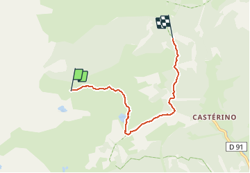

Length
5 km

Max alt
2320 m

Uphill gradient
9 m
Km-Effort
7.1 km

Min alt
1711 m

Downhill gradient
602 m
Boucle
No
Creation date :
2020-06-27 11:37:52.855
Updated on :
2020-07-03 15:55:19.328
1h53
Difficulty : Very easy

FREE GPS app for hiking
 SityTrail
IGN / Geographical institutes
SityTrail Plus
The world is yours!
About
Trail Walking of 5 km to be discovered at Provence-Alpes-Côte d'Azur, Maritime Alps, Tende. This trail is proposed by aris.
Positioning
Country:
France
Region :
Provence-Alpes-Côte d'Azur
Department/Province :
Maritime Alps
Municipality :
Tende
Location:
Unknown
Start:(Dec)
Start:(UTM)
377617 ; 4884479 (32T) N.
Comments